The North Fork of the Big Lost River contains some of the most scenic and isolated regions in the state. The highest summits in the Boulder Mountain Range also lie here will elevations approaching 12,000 feet.
🚗 Access
Access is via a good road that is passable to passenger vehicles until it reaches a gated section. Beyond the gate, the road becomes suitable only for those with the highest-clearance vehicles. This stretch is more appropriate for:
- Motorcycles
- E-mountain bikes
- Mountain bikes
🐟 Water Features
All streams, beaver ponds, and mountain lakes in the area are fishless.
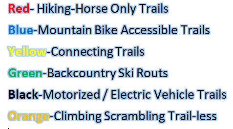
🥾 Trails & Navigation
While older maps of the region show a trail leading to the North Fork Lakes, today that trail is virtually non-existent. A maze of roads crisscrosses the region, so excellent map-reading skills are essential to find your way to the high mountain lakes.
📍 See the interactive map for the best route to the North Fork Lakes.